Route & what to see
![]()
|
A Brentford Walk Route & what to see |
|
london-footprints.co.uk |
A 3¾ mile walk from Kew Bridge to Brentford Station looking at remnants of the commercial & industrial past and new developments. Syon Park and Boston Manor Park are accessable from the route.
From Kew Bridge Station
right along Kew Bridge Road
The Kew Bridge Steam Museum occupies former buildings of the
Grand Junction Waterworks Company. Further along are the new
premises of the Musical Museum.
Cross into Waterman's Park
and walk through
This was the site of gasworks demolished in 1965 (the gasometers
were on the opposite side of the road). There is a view of the
former St George's Church designed by Arthur Blomfield in 1887.
Just beyond the park is the Watermans Art Centre, built in 1982-4
on the site of a brewery.
Cross Brentford High Street
and go along Ealing Road by MacDonalds. First left into Albany
Road.
The angled pipe on the right was used to fill watercarts. Further
along are cottages of the 1880s. There are also four houses built
with blocks made with gasworks clinker. The alley to the left
just beyond these was once Kings Arms Alley and the workshop on
the left occupies stabling of the former inn.
Cross the recreation ground
to the church
St Paul's was built in 1868 by F & H Francis but remodelled
in 1990.
From St Paul's Road left
into Half Acre
On the corner with the High Street is the Beehive Pub designed by
Nowell Parr & A E Kates in 1907. It is decorated with a bee
skep and Doulton tiles.
Left at Brentford High
Street
In front of the County Court building is a granite column
recording Brentford's historic events.
Cross and go down Pump Alley
At the end some buildings remain associated with the Brentford
Sewerage Pumping Station of 1883.
Continue around Town Meadow.
Right at Brentford High Street.
The fire station was designed by Nowell Parr in 1897. It was
extended in 1912 and last used in 1965. There are some former
firemen's houses behind.
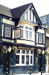
Go along Ferry Lane
The Waterman's Arms features attractive tiles. To the left would
have been malthouses and to the right Thames Soap Works, closed
in the 1960s.
Go to the right through the
new development, around inlet and then follow water edge.
Continue along the footpath (River Walk) which goes back to the
High Street.
There are still operational boatyards here.
Left at the High Street then
left into Dock Road
This is paved with fanned granite setts. The fence on the left is
supported by rails from Brunel's broad gauge railway. The gabled
building on the right was Underwood's Hay & Straw Depot.
After crossing the river
follow the gravelled path to the left along the water edge.
On the left is the River Brent/Grand Union Canal. The marina on
the right was the Brentford Dock opened in 1859 as an interchange
between the Thames and GWR. The area around this was occupied by
railways sidings and goods sheds, last used in 1964 and replaced
with housing in the 1970s.
Cross the entrance to the
marina and continue along the path. Where this becomes private go
up the steps into Augustus Close and go left here. At the
T-junction go right along Justin Close and just before the estate
office go through to the left. On this side of the bridge take
the steps down to the towpath and follow this along.
A single lock was opened in the early 19th century which was
doubled and mechanised in 1962. Beside the lock keeper's house is
the base of an engine house which would have provided hydraulic
power.
At the end take the steps up
to Augustus Close and go right
The road bridge once carried the Great Western & Brentford
Railway from Southall to Brentford Dock. It was opened in 1859
and converted to standard gauge in 1876. At the junction with the
High Street is St Lawrence's Church designed by Thomas Hardwick
in 1764 and retaining a 15th century ragstone tower. It closed in
1961 and is currently derelict and boarded up.
At the main road go left
On the right are the remnants of the railway line and station
(Brentford Town) which served the Brentford Dock
To access Syon Park continue along this road. There is a pedestrian entrance opposite the Post Office building.
To continue the walk cross
the High Street and Commerce Road
The first bridge across the Brent was built in 1280 and rebuilt
in stone in the 15th century. The present bridge was constructed
in 1824.
Go down to the locks and use
the footbridge to cross
These are gauging locks where tolls would be calculated and
charged to canal users according to type and weight of cargo. The
toll office building dates to 1911.
Use the road bridge ahead
(not the wooden footbridge) to return to the High Street and go
left
The market house was replaced by a town hall and police court in
1850. The present magistrate's court, extended in 1929, now
occupies the building.
Go behind the court building
On the corner is another tiled pub with riverside garden,
formerly the White Horse it has been re-named the Weir. The house
next door has a plaque recording the fact that the artist JMW
Turner lived there as a boy with an uncle.
Go alongside the pub into
the Butts
Backing onto the river is the Boatmen's Institute, an Edwardian
building by Nowell Parr on the site of a watermill. It provided
medical care, schooling and a meeting place for canal families.
Houses in the Butts were built from the 1690s. In the 18th
century the square was used for the hustings of the Middlesex
elections.
Exit on the far side
There are convent buildings on the right hand side.
Left along Boston Manor Road
The library (designed by Nowell Parr) was opened by Andrew
Carnegie in 1904. On the corner are war memorials.
Detour via Windmill Road
into Clifden Road
The public baths, also by Parr, were opened in 1896. The building
has been cleaned but is currently unused and boarded up. The
circular holes in the brickwork were made with coins!
Return to and continue along Boston Manor Road. Brentford Station is on the right.
To access Boston Manor Park continue along Boston Manor Road crossing towards the Glaxo Smith Kline building at the Great West Road. The entrance is just beyond the flyover on the left.
Resources
Village London by Andrew Duncan
© london-footprints.co.uk 2008
[places to visit] [walks list]