A Beckenham Walk
Route & what to see
|
A Beckenham Walk Route & what to see |
| london-footprints.co.uk |
This 3 mile walk starts at
Beckenham Junction Station and finishes at the War Memorial from
where there are buses or you can walk back to the station via the
High Street or Rectory Road. There are plenty of places for
refreshments along the High Street or you may like to stop on the
route which passes through two parks.
A Quiz Walk variation of this walk is available on the site [click here]
From Beckenham Junction
Station cross at the lights to the Green
This owes its existance to the Luftwaft as it was a densely
developed area, including the Railway Hotel, before WWII bombing
(see information board).
Walk along to the parish
church
The small village church was rebuilt between 1885-1903 to the
designs of W Gibbs Bartlett. There are some attractive post-war
stained glass windows, a number of memorials and a coffin cart.
The lychgate is 13th century, repaired in 1924 to commemorate two
Thornton brothers killed in WWI (see plaques). Across the road is
a milestone first erected in 1713.
Turn left into Bromley Road
The restaurant building next to NatWest Bank occupies the site of
the Old Manor House, owned by the St John, Cator and Hoare
families. It served as council offices until 1932. The adjoining
Public Hall was designed by George Vigers in 1883. Next to this
was Beckenham's second fire station built from the manor house
stables in 1905. The engine house has been rebuilt as flats but
some firemen's houses of 1926 remain. Anthony Rawlins, a city
merchant, died in Beckenham in 1694 and left 50 with which the
vestry built almhouses. The three cottages have been modernised
and still serve as almshouses. Bromley Road infant's school was
originally built in 1818 as a National School with 2 classrooms
and a master's house. It was extended in 1906.
Continue along Bromley Road
and past the shops turn right into Crescent Road
There is an old coach house at numbers 2B & 2C. The
Congregational (later United Reformed) church was built in 1875.
This was converted into flats as Spire Court.
Go first right through Limes
Road
Stanley Cottages were built in 1874
At the 'Jolly Woodman' go
left down Chancery Lane - or stop off for a pint!
This lane is shown on a map of 1769. The oldest properties are
numbers 29-43 including the blacksmith's forge at number 39 which
was still operating in 1902. There is a more uniform mid-19th
century terrace opposite.
Go left along Wickham Road
The weatherboarded buildings are some of the oldest in
Beckenham. The former wig factory has been converted into a
residental property.
First right into Court Downs
Road. At the end of the road enter Kelsey Park on the left
This was part of Kelsey Manor. The grounds were purchased for
public use in 1913 and the house demolished in 1921.
Beyond the flower beds cross
the river to the left and continue along the path.
The River Beck which runs
through the park has been dammed to form the lakes. A variety of
birds are to be found including herons which nest on the island.
It is also popluar with colourful parakeets!
Where the path divides bear
left for the cafe (adjacent to the playground). From behind the
cafe return to and cross the bridge between the lakes or continue
along and cross at the end of the south lake. In either case
follow the lakeside path to the right.
Beyond the rose garden to the left was the site of the
Kelsey Manor House. After serving as a Hoare residence it became
a school and then a WWI hospital.
Beyond the ornamental flower
beds take either the lower lakeside path or the upper path.
The Friends of Kelsey Park have an information centre here
(open weekends).
At the end of the lake exit
to the left into Manor Way and go right
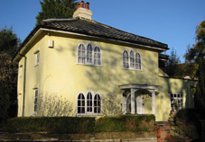
The large houses here were built from 1912-1937. The yellow house
with arched windows (pictured in header) was a tied cottage for
the baliff of the Kelsey Estate.
Take second left along
Stanmore Terrace and go right into Burnhill Road
The Coach & Horses pub is 18th century.
Go through Kelsey Square
into the High Street
This was an entrance to Kelsey Manor with a lodge of 1864 and
estate workers cottages. The barbers on the corner occupies the
first fire station premises which had local board offices above.
There is a restored pump with a lion's head on this building.
Go left along the High
Street
The entrance to the new development is on the site of the former
police station, used until 1884 (demolished 1936).
First left into Village Way
The corner chemist's shop stands on the site of the Pavilion
Cinema of 1914. The Catholic church, dedicated to St Edmund, was
designed by J O'Hanlon in 1937.
Just past Sainsbury's
delivery entrance follow the sign into the Recreation Ground and
take the track across the grass to the children's playground.
Then take the path going right towards the exit alongside The
Beacon.
The park opened to the public in 1891.
Go right along Croydon Road
The cottage hospital opened in 1872 with 4 beds and charged
patients 6d per day. The original building has been incorporated
into the new health centre.
The walk finishes at the War
Memorial
The cinema opposite opened as the Regal in 1930 replacing the
Pavilion. It was refurbished and its Art Deco features restored
several years ago but the popular ballroom was lost to provide
additional screens.
london-footprints 2017
[almshouses] [walkslist]